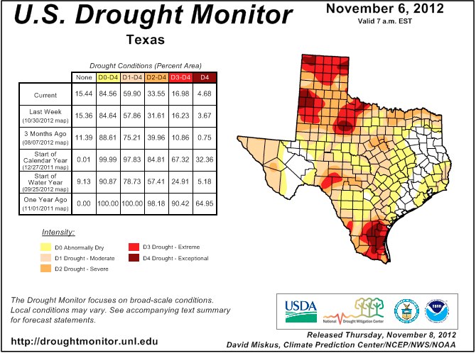
It wasn’t all that long ago when Houston emerged from an extended drought. But it now looks like this area is on the verge of another one. Over the last few months, temperatures have been unusually warm, and rainfall unusually light.
“We’re seeing departures from normal in the Houston area anywhere from 4-to-8 inches. And even some approaching 12 inches.”
 Brian Fuchs is a climatologist at the National Drought Mitigation Center at the University of Nebraska. The latest map from the center shows abnormally dry conditions in parts of Harris, Fort Bend, and Montgomery counties. Those abnormally dry conditions cover all of Brazoria, Galveston, Chambers, and Liberty counties. Fuchs says an upgrade could come very soon.
“Without any significant precipitation over the next week or so, I think it would almost be time to start introducing that “D-1″ drought on the U.S. Drought Monitor.”
Fuchs says two factors are behind the area’s dry spell — a quiet tropical storm season in the western Gulf, and a much weaker-than-expected El Nino. That’s a warming of the waters in the tropical Pacific. El Nino usually results in stormy conditions in the southern U.S.
This week, NOAA called off its El Nino watch, predicting there will be no meaningful warming or cooling in the Pacific — a phenomenon some refer to as “La Nada.”
(Hear the story at KUHF Public Radio)
RELATED STORIES:
- The “D” Word: It’s Time to Start Talking Drought Again (Houston Chronicle)
- U.S. Endures Near-Record Wildfire Season (USA Today)
- Warmer Still: Extreme Climate Predictions Appear Most Accurate, Report Says (Washington Post)
OTHER LOCAL AREA HEADLINES:
- Judge rules in unusual custody battle of surrogate twins (KTRK 13 News)
- Building bonds to generate jobs (KRIV 26 News)
- Speech on workplace rights not welcome at Lone Star College (Houston Chronicle)
- Jessica Tata jury may consider lesser charges (KPRC 2 News)
- Feds deal ‘devastating blow’ to Aryan Brotherhood prison gang (KHOU 11 News)
- Parents of gravely-ill child battle CPS (KRIV 26 News)
- Cross-country runner carries flags for fallen service members (Houston Chronicle)
- New memorial comforts families (Houston Chronicle)
STATE, NATION & WORLD:
- Texas Capitol to get Vietnam War memorial statue (AP)
- Business group calls for higher, more fees for water meters, vehicles (Austin Statesman)
- Western Governors University’s Texas branch marks 1st commencement (Austin Statesman)
- Federal judge urged to approve BP settlement (Houston Chronicle)
- Racial slurs at college protests prompt a deeper look (USA Today)
- Post-Sandy outages at 166,499 in 3 eastern states (AlertNet/Reuters)
- Hurricane Sandy and the Disaster-Preparedness Economy (New York Times)
- Malaria vaccine for infants disappoints in study (CBS-News)
